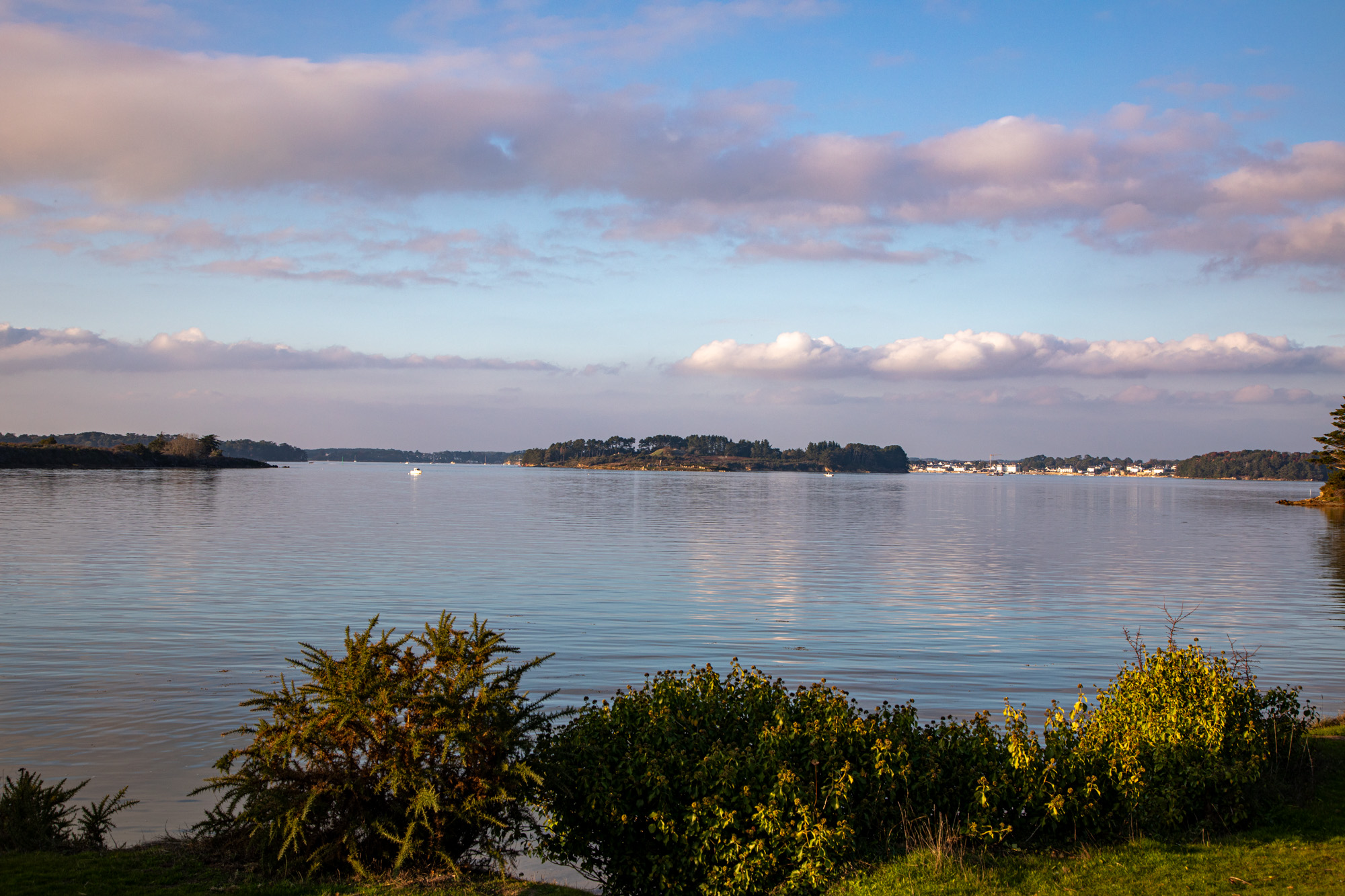
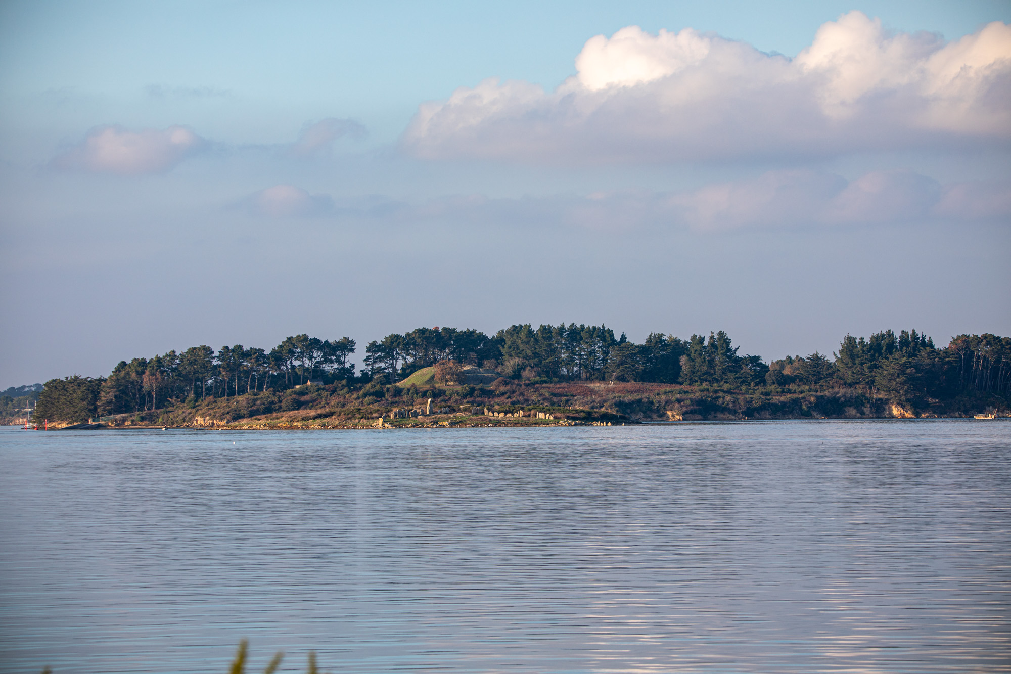
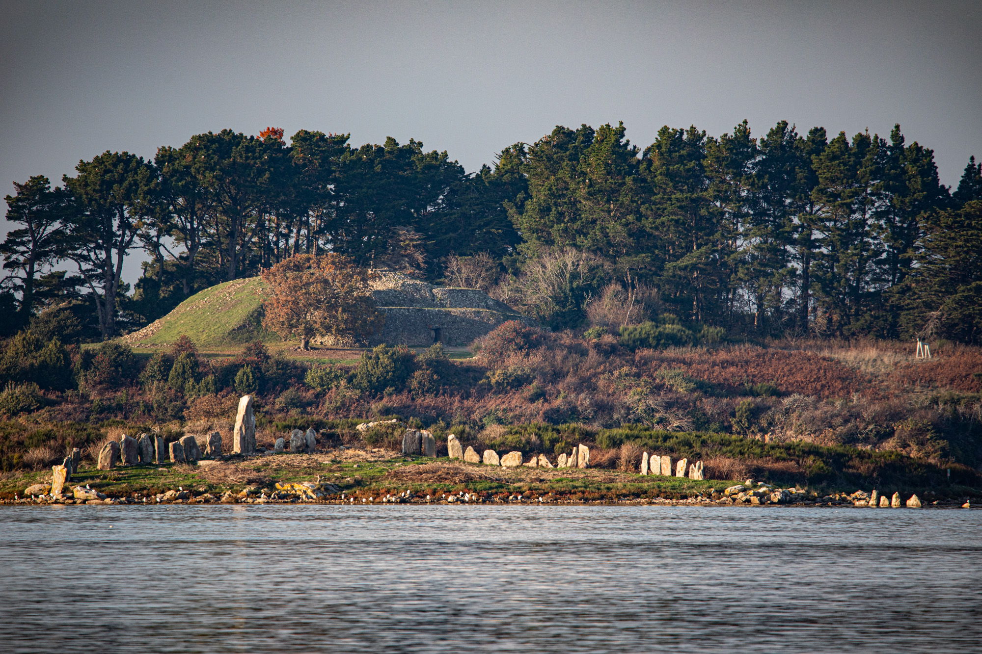
I visited Gavrinis years ago after a visit to Plouray. It was mind blowing, but the more long lived memory was of a half submerged stone circle that looked more like an animal pen than some cosmic instrument. I went back to Brittany with Isobel and whilst we were not able to take a boat trip to Gavrinis out of season, we had a great golden hour view of the site of Er Lannic. As I was getting out of the car camera in hand, something like an old Dakota flew across the island in front of us, a plane that seemed out of time in itself.
Across the Gulf of Morbihan at golden hour.Er Lannic, with the Gavrinis cairn among the trees behind.The restored stone arc on Er Lannic, Gavrinis behind it.
I couldn’t find a guidebook, so I picked up a more technical book on the site, but it was in French, so I’ve had a few bits translated.
From Serge Cassen, Er-Lannic (Arzon, Morbihan). Les stèles gravées néolithiques et la folle image: the preamble and opening section, translated by Claude.
Preamble
Enclosure arcs made of standing stones are an architectural feature found only in the part of the Morbihan that runs from the Ria d’Étel to the Ria de Pénerf. Since the 19th century we have tended to link them with the great stone rows, the region’s other striking peculiarity. Yet the site of Er-Lannic shows the opposite. We will come back briefly to this surprising form of Neolithic monumentality at the end of the volume. The main aim of this study is to stay focused on the symbolic images carved on some of the stones in one of the two great enclosure arcs: the one on the southern slope of the islet, which is easy to see because it has been restored.
Being an island naturally adds to Er-Lannic’s reputation. The monoliths rising out of the water at spring tides leave a lasting impression on visitors who get the chance to sail round the site on their way to or from a trip to Gavrinis, another iconic monument of the study area. Every island and islet nearby has its own tomb, stone row or settlement from the same period. Even so, Gavrinis and Er-Lannic together seem to work fully as the essential image of what we have come to call “megalithism”. It is a little like having the Table des Marchands and the Grand Menhir at Locmariaquer in one place, even though their dates are enough to show they were two separate building episodes. At Er-Lannic, though, the sea dominates the view, and it seems to join the regular curve of standing stones to the great mound behind it. In fact, Gavrinis and Er-Lannic stand on opposite banks of the Vannes river. They are two separate architectural ideas, and the fierce current of La Jument has run between them, in on the flood and out on the ebb, ever since they were built.
After a history of past research, we present each carved group of stones in the same way, using the same methods and the same style of illustration, and document every motif, whether it is certain or only probable. We do not describe the technical processes behind these results in full, since they are covered elsewhere; we only summarise the main steps. Our working sequence is deliberately strict so that the work can be repeated. That way our choices can be understood, our drawn recordings checked, and our conclusions tested against the same digital and graphic sources.
To close the book, a look back at the carved imagery recorded across the Morbihan will help put the signs described at Er-Lannic in context. Finally, a few concluding sections cover how the stones of the enclosure arc were arranged, and how the site would have looked in the Neolithic, when the sea was lower than it is today.
The site
The first to report the standing stones forming an enclosure on the islet of Er-Lannic was G. Thomas de Closmadeuc, during his explorations of the Gavrinis monument. He did so in 1866, in a talk to the Société polymathique du Morbihan, and mentioned the extraordinary quantity of pottery and stone remains on the site. It was not until his 1882 publication, though, that the same researcher revealed the second enclosure, which is under water and thought to be circular. He had seen it at a big tide on one of his visits in 1872 (Thomas de Closmadeuc 1882). The article does not mention it, but H. Dryden and W.-C. Lukis had gone with him to the island in 1868, after a trip to Gavrinis. They used the visit to draw a fairly accurate plan (and certainly a less inaccurate one than Thomas de Closmadeuc’s of 1882), and they too estimated the extent of the second, submerged group. All the stones were lying down except five standing on dry land (nos. 47, 48, 50, 67 and 85). These are clearly marked on the unpublished plan reproduced in the book; a less detailed version of it was published by W.-C. Lukis in 1872.
Between 1923 and 1926, Z. Le Rouzic and M. and St.-J. Péquart excavated and restored the site. Their plans corrected the wrong geometry of the stone setting drawn by G. Thomas de Closmadeuc (Péquart, Péquart 1926; Le Rouzic 1930; Gouézin, Le Gall 1993). These records raise the number of stones standing before restoration to six. The small stele 86, which W.-C. Lukis missed, is correctly placed by R. Merlet around 1919, and Z. Le Rouzic also lists it as standing before restoration; the vegetation, quite tall in some years, may have hidden it from the first visitors. Today we can add to this picture: stele 29, still standing in the submerged area; slab 129, set on edge in the north-eastern row; and stele 176, still upright near the rock outcrop at the top of the island.
Despite the corrective work of Le Rouzic and Péquart, the idea persisted that these settings belong to the large family of stone circles (“cromlechs”) found across western Europe (Thom, Thom 1978; Briard 1990; Burl 1995; Patton 2002). The vocabulary did change over the years, and the groups came to be called “hemicycles” or “enclosures”. In truth, neither word describes them accurately. If the second is to be kept, “enclosure arc” would better sum up these curved settings of standing stones. They are always open, and the sizes and orientations of their chords vary widely, as we will see in the conclusion.
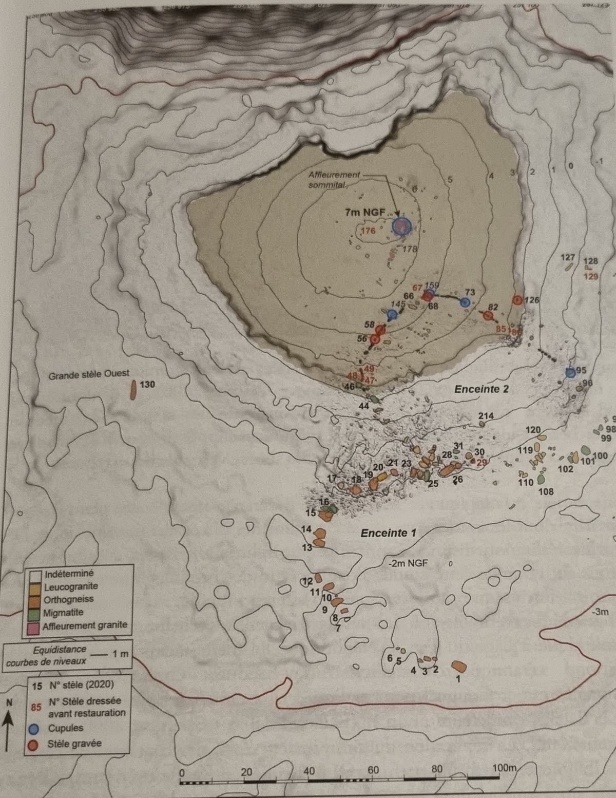
The two main monumental structures at Er-Lannic may touch, or meet at their ends. They have not yet been studied seriously, and our surveys at very big tides in 2014 and 2015 found still more blocks next to them, including a straight submerged row east of the islet. Enclosure arc no. 2 is built from a variety of rocks: two types of migmatite; an orthogneiss; a quartz, in the wall of cist no. 51 in Le Rouzic’s numbering; and two types of granite (biotite-muscovite leucogranite), plus another, roughly porphyritic granite whose source has not been found. In contrast, the underwater structure, no. 1, is made mostly of orthogneiss slabs, only occasionally interrupted by stones of “local” granite or migmatite.
Fig. 8: plan and rock types of the stelae recorded on the islet and foreshore of Er-Lannic (surveys by Obeltz, Celo, Audren, Cassen, Chaigneau, Menier, Querré and Vigier, 1990–2021; sources: Litto3D® and 2016 lidar, OSUNA/DRAC Bretagne). Key: white = undetermined, yellow = leucogranite, orange = orthogneiss, green = migmatite, pink = granite outcrop; red numbers are stelae standing before restoration; blue circles mark cup marks, red circles carved stelae. The red line is the probable highest water level in the Middle Neolithic.
As is known, orthogneiss comes from the Rhuys peninsula, and the nearest source of the right size, reachable on the foreshore, is Pen Castel at Arzon (Bonniol, Cassen 2009). Migmatite is plentiful near Port-Navalo, in the same commune, but similar rocks have also been recorded on the other side of the estuary, at Kerpenhir in Locmariaquer. Quartz is rarer, but veins have been recorded on the Rhuys peninsula (Chauris 2009), near Penvins (Sarzeau). At Port-Navalo (Arzon), depending on the tide, the foreshore also shows a workable vein where open joints in the surrounding granite would make it easy to extract slabs (see the Gavrinis report, Cassen et al. 2013). In other words, these rocks tend to come from the area south of Er-Lannic, within 5 km. The source of the leucogranite is harder to pin down. It is a common rock in the local bedrock and makes up most of the archaeological structures on the islet. The usual reflex (looking for the least effort…) is to place the source in the bedrock directly underneath, but in the Neolithic far more was at stake when it came to symbolic buildings. The leucogranite stelae preserved under the mound of Lannec-er-Gadouer (Boujot, Cassen 2000) showed this: the outcrop covered by the mound, sound and suitable for the sizes needed, was not the quarry it was assumed to be, and the real source of the stone lay a few hundred metres away.
On top of this variety of rock, the two arcs are laid out quite differently, with their chords pointing in different directions. They may have been built at different times, as we will see at the end of this study. In any case, this uncertainty about dates is built into the site. It was dug long ago without any real recording of layers, and the finds range from the late Mesolithic to the Iron Age. The Neolithic alone is represented by the Castellic, Auzay-Sandun, Groh-Collé, Kerugou, Bell Beaker and Conguel pottery traditions, to name only the most visible between the 5th and 3rd millennia BCE (Bailloud 1975; Salanova 2000; Hamon dissertation 2003). The site is also famous for the hundreds of broken pedestalled bowls (“incense burners”) recovered in excavation and in surveys of the foreshore, which we will come back to briefly.
The archaeological work of the 1920s produced more accurate plans and gathered plenty of pottery and stone tools, but it did little to explain what the monument (or monuments) was for. Z. Le Rouzic recorded about sixty structures during the excavations he carried out with St.-J. Péquart from 1923 to 1926. His apparently detailed measurements are often repeated in the scientific literature, but they are of limited value given how poor the digging was, even for the time. They say almost nothing about what these small stone arrangements were for. They very probably range from heaps of rubble, more accidental than man-made in their geometry, to a walled burial cist, by way of packing stones for old posts (Le Rouzic 1930). Between the “ritual hearths” Le Rouzic glimpsed and the “burial mound with side-by-side internal cists” suggested by P.-R. Giot (Giot 1998, p. 540), archaeologists’ readings of the site rest on limited evidence, and evidence limited to the buried parts at that. The monument itself has only really been discussed by followers of an archaeoastronomy with no sound method (Merlet 1974, surveys of 1919). Calculations based on inaccurate plans and on arbitrary alignments, picked because they fitted a preconceived idea, were nonetheless freely repeated by several generations of researchers (the winter-solstice orientation of the submerged hemicycle, for example). Before our work, the most detailed and accurate plan counted 119 blocks (Gouézin, Le Gall 1993). We have since corrected it with repeated measurements taken whenever the big tides allowed, and completed or checked it using lidar survey flights (Guyot et al. 2019, and work by P. Launeau/OSUNA), bringing the total to over 200 blocks.
The carvings were not listed in G. Thomas de Closmadeuc’s corpus (Thomas de Closmadeuc 1873). They were discovered when the monoliths were set upright again, having clearly been protected on the faces buried in the ground (Péquart et al. 1927, p. 42). They look very fresh in the photograph of block 58 in that publication, whereas after a century of weathering they can barely be made out. Three stelae of enclosure arc no. 2 are involved, but the authors hint that others may still carry carvings (which we will confirm); the rock, however, is too worn for photographs to show them (Péquart et al. 1927, p. 20). The carvings traced on overlays laid on the photographs are not discussed specifically in the 1927 Corpus. Two polished axe blades are identified on two stelae, though. Other, much deeper carvings on a third monolith are not reproduced, and it took the work of E. Shee Twohig (Shee Twohig 1981) for a drawn record of them to be offered. She also made a previously unpublished record of a block carved with parallel lines, found in excavation or in field survey in the 1920s or 1930s, which was not mentioned in the Corpus either. Finally, in an unpublished report to the Ministry of Fine Arts dated 1938, Z. Le Rouzic noted a slab that seemed to him to be carved, and we did indeed find it again during a visit to the site (Le Rouzic report 1938).
Our digital recording began in 2016 with photographic sessions under an opaque tent (stelae 82, 56 and 58). It resumed in 2017 after E. Vigier, then director of the Carnac Museum of Prehistory, passed on to us the unpublished information in the Le Rouzic report just mentioned (slab 126). Finally, a hint of a carved line spotted during that recording (stele 68) brought us back in 2018 for a further survey, this time at night, because the monolith was too big to cover easily with a gazebo tent. We systematically checked all the inner faces at night, and some of the outer faces as well, but found nothing more to add to the list: 5 slabs with carvings, 2 slabs with cup marks, 2 stray blocks with cup marks, and an outcrop in the middle of the islet covered with at least thirty cup marks, likewise previously unrecorded.
I lost a load of photos in a hard drive failure, including my old photos from a boat. Hopefully one day will visit again!
I appreciated the dismissal of the alignment to the solstice in the text, and it minded me that there were noticeably few crystal new age shops in Morbihan. Thinking that if Morbihan was in the UK it would be awash with druids and associated merchandising I did a bit of googling which stated that France was less officially tolerant to mysticism (cheers Voltaire), certainly the museums we went to did not indulge much in fantasy and encouraged a more materialistic facts only interpretation of their ancient monuments.
The irony is that the solstice idea at Er Lannic isn’t ancient at all. It goes back to René Merlet’s surveys of 1919, and it got a long second life from the fashion for megalithic astronomy that Alexander Thom, the Scottish engineer, did so much to spread on both sides of the Channel. His Megalithic Remains in Britain and Brittany (1978, with his son) is one of the works Cassen cites for the “cromlech” reading he pushes back on. So the jarring of the image of an obviously functional animal pen rather than a cosmic instrument was due to these ideas I’d thoughtlessly accepted over time.
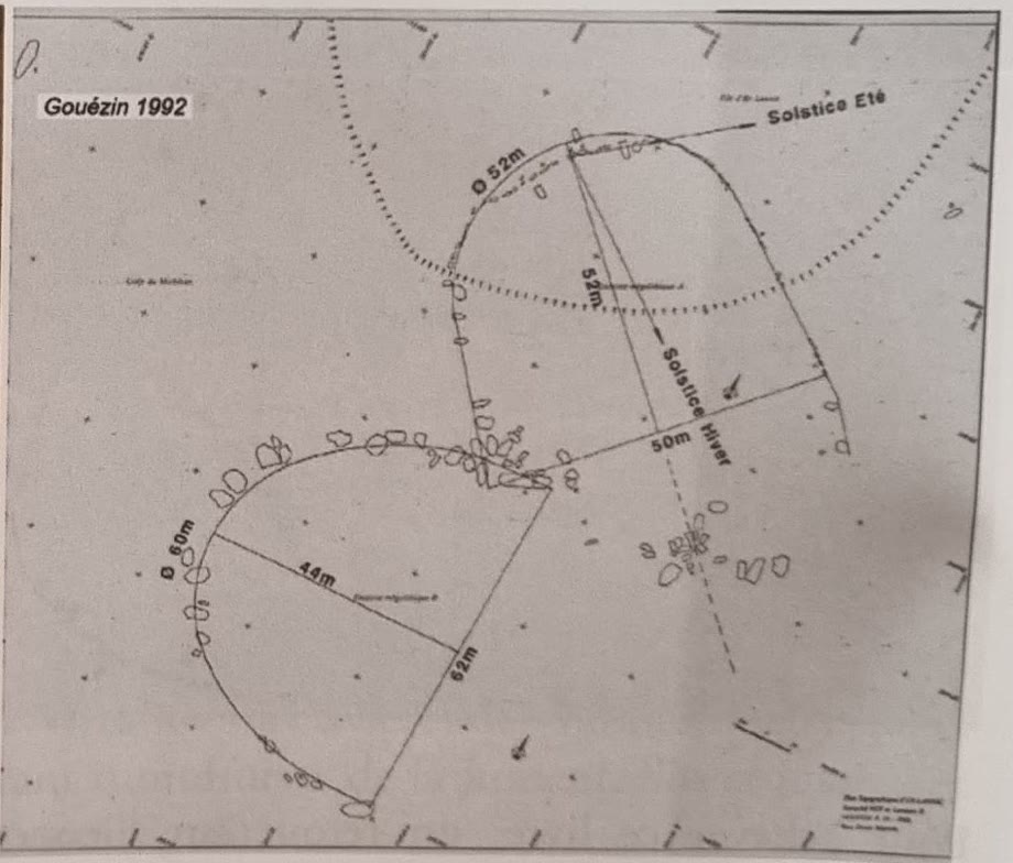
The book sets the old plans of the site side by side, and the last of them, Gouézin’s from 1992, shows the idea at work. The stones are all there, but the two arcs have been tidied into compass curves with their diameters written on (52 m and 60 m), and ruled lines run off across them labelled Solstice Été and Solstice Hiver. It was a good survey: the version Gouézin published with Le Gall the following year was the most accurate plan of Er Lannic until Cassen’s team came along, with 119 stones on it. That’s what makes it telling. The geometry and the sun lines were drawn on top of careful fieldwork, and once they were on the plan they looked like part of the evidence.
Gouézin's 1992 plan, from Fig. 4 of Cassen's book: the arcs drawn as geometric curves, with summer- and winter-solstice lines ruled across them.
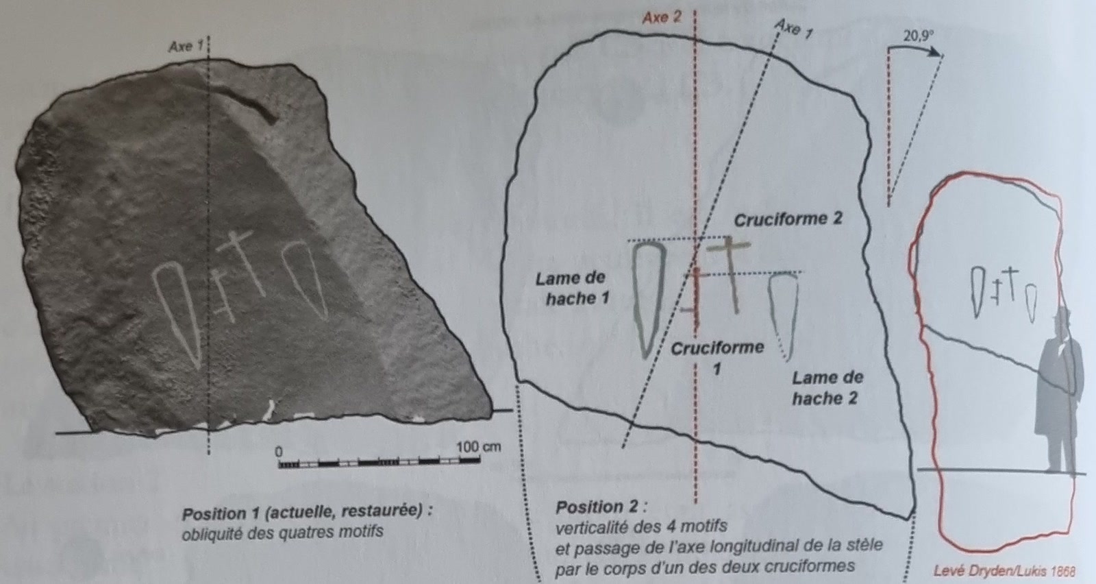
The restorers left their mark on the stones as well as the plans. Stele 58, in the island arc, was lying broken on the ground when Le Rouzic and the Péquarts put it back up in 1925, and they set it at a lean. Its carvings, two polished axe blades and two cross shapes (the second blade only turned up in 2018, under virtual raking light), all slant with it, and for a century that’s how they’ve been drawn. Cassen went back to a plan Dryden and Lukis made in 1868, when the stone was still down. Their outline of it matches his 3D survey, and once the stone is turned to fit it, about 21 degrees, its sides come out roughly upright and so do all four carvings. The stele’s long axis runs straight through the smaller cross, and the signs fall into pairs at the same height: the big blade level with the big cross, the small blade with the small one. Nothing in the 1920s photographs suggested it needed setting at a slant. It’s a small thing, but the stone had stood at the wrong angle for a hundred years, and its carvings had been read at that angle too.
Stele 58, from Fig. 25 of Cassen's book: as restored in 1925 (left), and turned about 21° to match Dryden and Lukis's 1868 outline (red, right), which stands the axe blades and crosses upright.
After writing this I found a short article by Cassen and two colleagues (Serge Cassen, Valentin Grimaud and Christian Obeltz, “Architectures monumentales néolithiques submergées en Morbihan”, Les Nouvelles de l’archéologie 156, 2019) which goes further than dismissing the solstice, and offers something in its place. Of the 173 stones they have recorded at Er Lannic, 84 are under water and 17 never show even at the lowest tides. Across the Morbihan coast as a whole there are over 1,500 drowned standing stones at 34 sites, a number that rarely makes it into the inventories of menhirs.
Their idea is that the two horseshoes were facing the sea. When the stones went up, the sea was several metres lower and still rising fast enough to be noticed. The opening of the drowned arc, the one the current boils over at big tides, runs parallel to a shoreline five to seven metres below today’s; the arc on the island opens onto a later shore two to four metres down. The stone tells the same story. The drowned arc is three-quarters orthogneiss, dragged from at least 3 km away, the same rock and the same effort as the Grand Menhir at Locmariaquer around 4500 BC, while the island arc is mostly local granite. So an older arc was built facing one coast, and when the water came up a newer one was built facing the next. Other arcs in the estuary, at Berder and Kerpenhir, do the same, turning to follow the coast as it moved. The orientation that generations of researchers read as a line to the midwinter sun is, on this reading, the edge of a sea that was coming in.
That still doesn’t say what they were for, and the authors are careful not to. But it makes a better mystery: a pen, a boundary, a threshold against the water, something people kept rebuilding as the land drowned around them.
Cassen had an earlier go at that question. In a 2003 paper with Jacobo Vaquero Lastres, “Le désir médusé” (in Jean Guilaine’s Arts et symboles du Néolithique à la Protohistoire), he starts from the carvings rather than the plans, and from the stone the drowned arc shares with the Grand Menhir and with a great carved stele that was later broken up and reused in two tombs, the Table des Marchand and Gavrinis: orthogneiss, dragged several kilometres and set up at the mouth of the Gulf, on the ridge where the land met the sea. For a century the carvings on that stele had been read as a farmers’ idyll: an ox pulling a plough, a mother goddess, a shepherd’s crook. Cassen and Vaquero take it apart sign by sign. The “plough” is a sperm whale breaching, the placid oxen are a bull and a ram with their horns exaggerated, the axe and the crook are weapons (a war axe and a throwing stick), and the “goddess” on the neighbouring Mané Rutual stone is, less delicately, an erect phallus. Read as a scene, the men and horned beasts of the land brace themselves against a monster leaping out of the sea. Around 5000 BC that wasn’t only a metaphor. The sea was rising far faster than at any time in recorded history, swallowing the plains off Carnac, and new people, new animals and new ways of living were arriving along the coast, some of them by boat from the south. A stone on the shore, facing the water, is a border post against something you can’t fence off. Which makes it all the stranger that the stones themselves are now going under.
None of this has stopped the romantics, and Brittany has had its share: the 19th-century Celtomaniacs were sure Carnac was built by druids, a good three thousand years too late, and there has been a Breton Gorsedd of bards and druids since around 1900. But it reads as a cultural society more than a shop front. Over here, Druidry has been recognised as a religion for charity purposes since 2010, and English Heritage opens Stonehenge to the crowds every solstice. France went the other way: it has a state body that watches over cults, and since 2001 a law against exploiting vulnerable people’s beliefs. Meanwhile the Carnac rows have been fenced off since the early ’90s, for the sake of the grass rather than the ley lines. The result is a landscape where the stones are left to be stones, and the guidebook spends its pages on rock types and tide levels rather than energy. I found that oddly more moving.